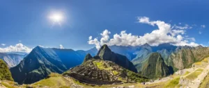
Machu Picchu’s elevation is approximately 2,430 meters, 7,972 feet, or 2.43 kilometers above sea level. This figure refers to the Inca archaeological site—not the summit of Machu Picchu Mountain, the nearby town of Aguas Calientes, or the highest point on the Inca Trail. Knowing that distinction helps you plan your visit, compare hiking routes, and understand where altitude could affect your trip.
This guide groups the essential Machu Picchu elevation questions into practical topics: measurement conversions, mountain summits, Cusco comparisons, hiking elevation gain, altitude sickness, and trip planning.
Machu Picchu Elevation Above Sea Level: Essential Measurements
How High Is Machu Picchu?
The commonly cited Machu Picchu elevation above sea level is 2,430 meters. The archaeological complex occupies a sloping mountain ridge, so its terraces, stairways, temples, and viewpoints do not all share one exact elevation. Treat 2,430 meters as the standard reference height for the site rather than a measurement that applies to every step. For visitors researching “Peru Machu Picchu elevation,” this is usually the number they need.
| Location | Approximate Elevation in Meters | Approximate Elevation in Feet |
|---|---|---|
| Machu Picchu archaeological site | 2,430 m | 7,972 ft |
| Aguas Calientes / Machupicchu Pueblo | 2,040 m | 6,693 ft |
| Huayna Picchu summit | 2,693 m | 8,835 ft |
| Machu Picchu Mountain summit | About 3,080 m | About 10,105 ft |
| Cusco | About 3,400 m | About 11,155 ft |
| Dead Woman’s Pass, classic Inca Trail | About 4,215 m | About 13,829 ft |
Elevations are rounded reference figures. Published measurements can differ according to the exact location surveyed, mapping source, or summit reference used.
Machu Picchu Elevation in Feet and Meters
If you are searching for Machu Picchu elevation in feet or “Machu Picchu elevation ft,” the standard answer is approximately 7,972 feet. The corresponding Machu Picchu elevation in meters is 2,430 meters. Some travel resources round these figures to 8,000 feet or 2,400 meters. Those approximations are useful for general comparisons, but they should not replace route-specific elevation information when you assess a demanding hike.
Understanding Small Differences Between Published Figures
Different sources may assign slightly different heights to Machu Picchu because the site covers uneven terrain rather than a flat platform. A measurement taken near an upper terrace will differ from one recorded lower in the complex. GPS readings also fluctuate. Small differences generally do not change travel planning: your recent ascent, sleeping elevation, activity level, and individual response matter more than a few meters of measurement variation.
Machu Picchu Elevation in Kilometers
The Machu Picchu elevation in km is 2.43 kilometers above sea level. Divide meters by 1,000 to convert elevation into kilometers. This measurement describes vertical height, not the distance you must walk or travel. It does not mean the archaeological site is a 2.43-kilometer hike from town. Road distance, trail length, elevation gain, and elevation above sea level are separate measurements, each answering a different planning question.
Base, Summit, and Highest Machu Picchu Elevation
Base of Machu Picchu Elevation: Aguas Calientes
The phrase “base of Machu Picchu elevation” usually refers to Aguas Calientes, also called Machupicchu Pueblo, at approximately 2,040 meters or 6,693 feet. This town provides accommodation, restaurants, train connections, and bus access to the archaeological site. It lies roughly 390 vertical meters below the standard citadel elevation. If a hiking description mentions a mountain’s “base,” however, it may mean a trail checkpoint rather than the town itself.
Top of Machu Picchu Elevation: Which Top?
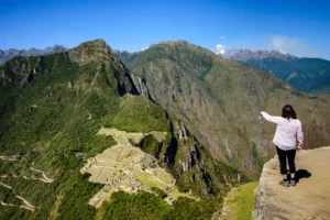
The top of Machu Picchu elevation depends on what you mean by “top.” Upper viewpoints within the archaeological complex remain part of the citadel area. Huayna Picchu is the steep mountain commonly seen behind the ruins in photographs. Machu Picchu Mountain is a separate, higher summit. These locations require different levels of effort and may involve different ticket options, so always identify the actual destination before comparing heights or booking access.
Mt Machu Picchu Elevation and Montaña Machu Picchu
Mt Machu Picchu elevation, also searched as “Montaña Machu Picchu elevation,” refers to Machu Picchu Mountain rather than the ruins. Its summit is commonly reported around 3,060–3,082 meters; using approximately 3,080 meters, or 10,105 feet, provides a practical planning reference. This places it roughly 650 meters above the citadel’s standard elevation. The climb is a substantial mountain excursion, not simply an extension of a gentle sightseeing walk.
Is Machu Picchu Mountain the Highest Nearby Visitor Summit?
Among the two best-known ticketed summit hikes associated with the archaeological site, Machu Picchu Mountain is higher than Huayna Picchu. It is therefore the usual answer to questions about the “highest Machu Picchu elevation” or “Machu Picchu elevation peak.” It is not, however, the highest mountain in the surrounding Andes. The distinction matters because regional trekking routes can reach much greater elevations than either summit beside the ruins.
Huayna Picchu Elevation Compared With the Citadel
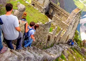
Huayna Picchu rises to approximately 2,693 meters, or 8,835 feet, around 260 meters above the citadel’s standard elevation. Despite being lower than Machu Picchu Mountain, it can feel demanding because of steep stone steps, narrow passages, and exposed sections. Height alone does not determine difficulty. Travelers uncomfortable with heights or with limited balance should consider the trail’s character, not simply choose it because its summit elevation is lower.
Machu Picchu Elevation vs Cusco
How Much Higher Is Cusco Than Machu Picchu?
For Machu Picchu elevation vs Cusco, the key comparison is approximately 2,430 meters versus 3,400 meters. Cusco is about 970 meters, or 3,182 feet, higher than the archaeological site. That difference helps explain why some travelers feel breathless or develop headaches after arriving in Cusco yet feel better farther down the valley. Nevertheless, descending does not guarantee that every symptom will disappear, especially when another illness is involved.
Cusco to Machu Picchu Elevation Changes
The overall Cusco to Machu Picchu elevation change is downward, but the journey does not always descend continuously. A road transfer toward the Sacred Valley can cross higher terrain before dropping to towns such as Ollantaytambo, around 2,790 meters. The railway then follows the valley toward lower Aguas Calientes. Finally, visitors ascend to the citadel by bus or on foot. A trekking itinerary follows a very different elevation profile.
Why Sleeping Elevation Matters
Sleeping altitude is important because your body spends many uninterrupted hours adjusting there. A first night in a lower Sacred Valley location may be easier than a first night in Cusco, although Sacred Valley towns have different elevations. Spending time lower does not automatically prepare you for a pass above 4,000 meters. Your plan should match the highest terrain and sleeping elevations you will actually encounter, not just your final destination.
Should You Visit Machu Picchu Before Exploring Cusco?
Some visitors choose lower accommodation soon after arrival, visit Machu Picchu, and explore Cusco later. This can reduce the abrupt increase in sleeping elevation, but it requires realistic transport connections and enough time to rest. Others acclimatize in Cusco before continuing. Neither sequence suits everyone. Consider your arrival time, health history, hiking ambitions, and flexibility, and avoid scheduling a strenuous mountain climb immediately after a long international journey.
Machu Picchu Altitude Sickness: Risks, Symptoms, and Prevention
Can You Get Altitude Sickness at Machu Picchu?
Machu Picchu altitude sickness is possible, although the risk is generally lower at the citadel than in Cusco or on high trekking passes. Acute mountain sickness becomes more common around 2,500 meters and above, but that is not an absolute cutoff. The ruins sit slightly below that reference level, and some visitors arrive already symptomatic from higher locations. Rapid ascent and individual susceptibility matter; excellent fitness does not provide immunity.
Machu Picchu Elevation Sickness Symptoms
People searching for “Machu Picchu elevation sickness” are generally asking about altitude illness. A typical acute mountain sickness pattern is a headache after recent ascent, accompanied by symptoms such as nausea, dizziness, or unusual fatigue. Poor sleep can also occur at altitude. Breathlessness while climbing stairs can be a normal response to exertion, but worsening symptoms or feeling ill at rest deserve attention. Dehydration, infection, and travel exhaustion can produce overlapping symptoms.
- Headache: particularly when it begins after ascending to a higher location.
- Nausea or reduced appetite: sometimes accompanied by vomiting.
- Dizziness: especially when combined with other altitude-related symptoms.
- Unusual fatigue: beyond what you would expect from the activity.
Warning Signs That Require Urgent Help
Confusion, inability to walk steadily, breathlessness at rest, or a worsening cough with marked weakness are emergency warning signs. They can indicate serious high-altitude illness or another urgent medical problem. Stop ascending, alert your guide or site staff, and arrange prompt medical evaluation and descent when safe. Do not allow a person with confusion or poor coordination to descend alone. Supplemental oxygen may help when available, but it should not delay appropriate evacuation.
How to Reduce Altitude Sickness Risk
The most useful strategy is gradual acclimatization. Keep early activity light, allow recovery time after arrival, and build flexibility into your schedule. Drink normally to maintain hydration, eat regularly, and avoid heavy alcohol consumption while adjusting. Excessive water intake does not prevent altitude sickness and can be harmful. If symptoms develop, do not continue higher to meet a timetable. Rest at the same elevation for mild symptoms and descend if they worsen or fail to improve.
- Choose a manageable first day rather than a strenuous arrival-day hike.
- Consider lower initial accommodation when transport arrangements allow it.
- Increase hiking effort gradually and monitor how you feel.
- Tell your guide or travel companions about symptoms early.
- Preserve enough flexibility to cancel a summit hike if necessary.
Medication, Coca Tea, and Personal Medical Advice
Ask a qualified clinician whether acetazolamide is appropriate for your itinerary, particularly if you have experienced altitude sickness before or cannot avoid rapid ascent. It is not necessary for every Machu Picchu visitor and does not replace sensible ascent planning. Coca tea is widely offered locally, but reliable evidence that it prevents altitude sickness is lacking. Coca products may also create drug-testing or border-control issues. Travelers with significant heart or lung conditions should seek individualized advice before departure.
Machu Picchu Elevation Hike and Elevation Gain
Elevation Above Sea Level vs Elevation Gain
Machu Picchu elevation gain means the vertical climbing completed along a particular route. It is different from the altitude of your destination. A hike finishing at 2,430 meters does not require climbing 2,430 meters if it starts in Aguas Calientes at 2,040 meters. Also distinguish net gain from cumulative ascent: net gain compares start and finish, while cumulative ascent adds every uphill section, including climbs made after intermediate descents.
Aguas Calientes to Machu Picchu Elevation Hike
Walking from Aguas Calientes to the entrance involves approximately 390 meters of net elevation gain, with actual cumulative ascent depending on your starting point and route. The trail includes sustained climbing and many stone steps. It can feel strenuous in warm, humid conditions, especially before a timed entry. Allow generous time based on your pace and current conditions, and remember that reaching the entrance is only the beginning of your walking day.
Walking Up vs Taking the Bus
Taking the bus conserves energy for the archaeological circuit and any permitted mountain hike. Walking may appeal to active travelers, but it adds exertion without replacing the need for admission reservations. A sensible decision considers your symptoms, knees, weather, and scheduled entry. If you plan to climb Machu Picchu Mountain afterward, using the bus can make the total day more manageable rather than combining two substantial uphill efforts.
Machu Picchu Mountain Elevation Gain
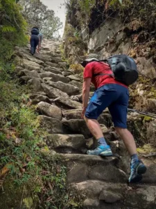
The difference between the citadel’s reference elevation and Machu Picchu Mountain’s summit is approximately 650 meters. Actual hiking elevation gain depends on the trail checkpoint, approach, and route measurement. Expect prolonged uphill walking on stone steps, followed by a descent that can be tiring for the knees. This option suits visitors seeking a sustained mountain outing, but its higher altitude makes acclimatization particularly relevant. Summit views also depend on cloud and weather conditions.
Huayna Picchu Elevation Gain and Difficulty
The summit of Huayna Picchu is roughly 260 meters above the standard citadel elevation, but this is not a precise cumulative-ascent figure for every permitted route. The climb can be intense despite the smaller height difference. Steep stairs and constrained footing reward a slow, deliberate pace. When comparing this Machu Picchu elevation hike with the mountain alternative, weigh exposure and trail layout alongside total climbing, especially if anyone in your group dislikes heights.
Elevation Changes Within the Archaeological Site
A regular citadel visit still involves uneven stone surfaces, stairs, and changes in level. The amount of climbing depends on the designated circuit, and not every admission option includes the same terraces or viewpoints. Visitors with limited mobility should investigate route details before purchasing tickets rather than assume the ruins are level because they are not booking a summit. Check current official access arrangements, since circuit names, permitted movements, and availability can change.
Inca Trail to Machu Picchu Elevation
Highest Point on the Classic Inca Trail
The most important Inca Trail to Machu Picchu elevation figure is approximately 4,215 meters, or 13,829 feet, at Dead Woman’s Pass, also known as Warmiwañusqa. This is roughly 1,785 meters higher than the citadel. Consequently, the classic trek presents a substantially different altitude challenge from a train-and-bus visit. Preparing only for Machu Picchu’s 2,430-meter elevation would underestimate the highest and potentially hardest portion of the route.
Inca Trail to Machu Picchu Elevation Gain
Inca Trail to Machu Picchu elevation gain is cumulative across repeated climbs and descents. The classic route generally starts around 2,600–2,800 meters, depending on the precise reference point, and ends lower at Machu Picchu, yet it still involves several thousand meters of climbing overall. Published totals vary with itinerary and recording method. Ask your operator for daily ascent, descent, distance, highest point, and campsite elevation rather than relying on one route-wide number.
Why Daily Trail Profiles Are More Useful Than a Single Total
A demanding day is shaped by how climbing is distributed. A long ascent toward a high pass can be harder than the same cumulative gain spread across lower, shorter walks. Long descents also create fatigue, particularly on stone steps. Review each day’s profile alongside walking time and overnight altitude. This helps you prepare physically, understand the operator’s pacing, and recognize why acclimatization days before departure are valuable even for experienced hikers.
Short Inca Trail Elevation
The Short Inca Trail commonly begins near the railway’s Kilometer 104 area and climbs toward Wiñay Wayna and the Sun Gate before reaching Machu Picchu. It does not cross Dead Woman’s Pass and generally stays much lower than the classic multiday route. Nevertheless, it involves a substantial uphill walking day, often in humid conditions. Ask for the specific itinerary’s elevation profile; “short” describes the route’s duration, not a guarantee of easy terrain.
Planning Your Visit Around Machu Picchu’s Elevation
Choose Your Route Before Booking Tickets
Decide whether your priority is the archaeological site, a mountain summit, or a multiday trek before finalizing reservations. These experiences have different physical demands and access arrangements. Check the current official ticket descriptions for circuit coverage, mountain access, entry times, and restrictions. Do not assume a general admission ticket includes Huayna Picchu or Machu Picchu Mountain, or that one route allows unrestricted movement throughout the complex. Align transport times with the exact visit you book.
Pack for Altitude, Sun, Rain, and Stone Steps
Bring comfortable footwear with dependable traction, sun protection, lightweight layers, and rain protection suited to the forecast. Carry drinking water within current site rules and plan food breaks around permitted areas. Machu Picchu can feel warmer and more humid than Cusco despite its mountainous setting, while exposed viewpoints can turn cool quickly. Pack lightly enough to walk comfortably, and verify current restrictions on bags, walking poles, and other equipment before arrival.
Prepare for the Whole Day, Not Just the Summit
Training should reflect your chosen itinerary. Regular walking, stair climbing, and gradual hill sessions help prepare your legs for repeated ascent and descent, but they do not eliminate altitude sickness risk. Include transport fatigue, early starts, entrance approaches, and sightseeing in your assessment of the day’s workload. A manageable itinerary leaves energy for enjoying the ruins instead of treating every available climb as compulsory. Weather, symptoms, and comfort should always take priority over a summit goal.
Frequently Asked Questions About Machu Picchu Elevation
Is Machu Picchu Higher Than Cusco?
No. Machu Picchu is approximately 2,430 meters above sea level, while Cusco is around 3,400 meters. Cusco is roughly 970 meters higher. That makes a standard citadel visit lower-altitude than a stay in Cusco, but optional mountains and trekking routes require separate comparisons. The classic Inca Trail’s highest pass, for example, rises well above both locations.
What Is the Highest Elevation You Can Reach at Machu Picchu?
Among the best-known visitor summit hikes beside the archaeological site, Machu Picchu Mountain is the highest, at about 3,080 meters. Huayna Picchu is approximately 2,693 meters. If your question includes the journey rather than only the destination, the classic Inca Trail reaches about 4,215 meters at Dead Woman’s Pass. Your ticket and itinerary determine which elevations you actually encounter.
Final Takeaway: Match the Elevation to Your Itinerary
Machu Picchu stands approximately 2,430 meters, 7,972 feet, or 2.43 kilometers above sea level. That answers the basic elevation question, but effective planning goes further: Cusco is higher, Aguas Calientes is lower, nearby summits add climbing, and the classic Inca Trail crosses a much higher pass. Compare the route you intend to take, allow time to adjust, and respond promptly to altitude symptoms. With realistic pacing, elevation becomes a manageable planning consideration rather than an unwelcome surprise.