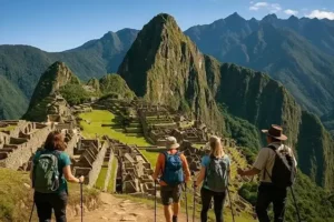
Machu Picchu is located in southeastern Peru, in the Andes Mountains of South America. The famous Inca archaeological site sits above the Urubamba River valley in the Cusco Region, approximately 75 kilometers northwest of Cusco in a straight line. Its elevation is about 2,430 meters, or 7,970 feet, above sea level. Although travelers often associate it with Cusco, Machu Picchu is not inside the city: reaching the ruins requires a separate journey through the Sacred Valley or along an authorized trekking route.
If you are asking “where is Machu Picchu located,” understanding the surrounding geography makes planning much easier. Peru is the country, Cusco is the main regional gateway, and Machu Picchu Pueblo—also called Aguas Calientes—is the nearest town. This guide explains where Machu Picchu appears on a map, which airport to use, how far it is from Lima and Cusco, and how the archaeological site differs from Machu Picchu Mountain.
Where Is Machu Picchu Located, and in Which Country?
Machu Picchu Is in Peru, South America
The answer to “where is Machu Picchu located in which country” is Peru. Peru lies on the western side of South America, bordering the Pacific Ocean. Its landscapes include coastal deserts, the Andes Mountains, and Amazonian rainforest. Machu Picchu occupies a particularly dramatic transition zone where steep Andean mountains meet humid, forested eastern slopes. This setting explains why photographs show both towering peaks and lush vegetation, rather than the dry, open landscapes many visitors associate with the central Andes.
Where Is Machu Picchu in Peru?
Within Peru, Machu Picchu belongs to the Cusco Region, Urubamba Province, and Machupicchu District. It stands on a mountain ridge above a winding section of the Urubamba River, away from Peru’s coastal cities. The location is northwest of Cusco, the former Inca capital, and beyond the principal towns most travelers visit in the Sacred Valley. Administratively and historically, the site belongs to the wider Cusco area, but it is geographically separate from Cusco city and requires dedicated transportation.
Machu Picchu Location at a Glance
These basic geographic details help distinguish the country, region, archaeological site, and nearby settlement. They are especially useful when booking flights or accommodation because travel websites sometimes use “Machu Picchu” to describe both the ruins and the town below them. Always check the actual address of a hotel or departure point rather than assuming it is beside the archaeological entrance.
- Country: Peru.
- Continent: South America.
- Region: Cusco.
- Province: Urubamba.
- District: Machupicchu.
- Nearest town: Machu Picchu Pueblo, commonly called Aguas Calientes.
- Archaeological site elevation: Approximately 2,430 meters above sea level.
- Main visitor gateway: Cusco and the Sacred Valley.
Where Is Machu Picchu on a Map?
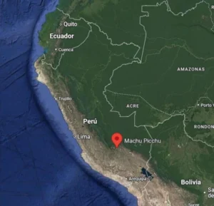
Map Coordinates and Geographic Position
Machu Picchu’s approximate coordinates are 13.1631° S, 72.5450° W. In digital map applications, enter -13.1631, -72.5450 to locate the archaeological complex. On a world map, first find western South America, then Peru, and finally the inland Cusco Region. Zooming in reveals a ridge surrounded by steep valleys and mountains. These coordinates identify the ruins rather than the railway station, town center, or summit of Machu Picchu Mountain, each of which has a different location.
Understanding the River, Ridge, and Surrounding Mountains
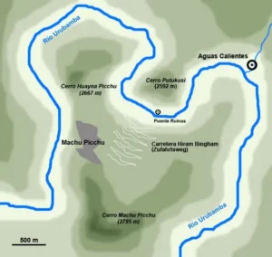
The Urubamba River curves around the mountains below Machu Picchu, creating the dramatic landscape visible in aerial photographs. The citadel occupies a ridge between the mountain commonly called Machu Picchu Mountain and the distinctive peak of Huayna Picchu. Forested slopes fall sharply toward the river, helping explain why the site remained relatively isolated from major modern transport corridors. When viewing a map, remember that a short horizontal distance can involve substantial elevation gain, switchback roads, or a journey around difficult terrain.
Which Map Pin Should You Use?
Choose a map pin that matches your immediate destination. “Machu Picchu archaeological site” points toward the ruins, while “Machu Picchu Pueblo” or “Aguas Calientes” identifies the town used for hotels, restaurants, and rail arrivals. “Machu Picchu Mountain” identifies a separate hiking destination above the citadel. Saving all three locations can prevent confusion, but navigation apps should not replace official visitor instructions: suggested walking routes may cross restricted areas or fail to reflect current access rules.
Where Is Machu Picchu City?
The Ancient Inca Citadel
When people ask “where is Machu Picchu city,” they often mean the ancient Inca settlement. The archaeological site contains terraces, plazas, stairways, residences, ceremonial spaces, and carefully constructed stone buildings. It is commonly called an Inca citadel, although scholars continue to investigate its functions. Many interpretations connect it with a royal estate associated with the emperor Pachacuti. It is not a functioning modern city with ordinary streets, hotels, or a resident urban population inside the ruins.
The Modern Town: Machu Picchu Pueblo or Aguas Calientes
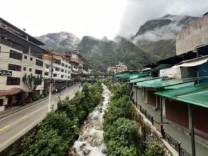
The modern settlement below the ruins is officially known as Machu Picchu Pueblo and widely called Aguas Calientes. Located beside the river at approximately 2,040 meters above sea level, it serves as the main overnight base for visitors. The town has accommodation, restaurants, shops, railway facilities, and buses to the archaeological entrance. Travelers frequently sleep here before an early visit or after arriving by train from the Sacred Valley. Its position in the valley means the ruins are still uphill, not immediately beside the railway platform.
Getting from Aguas Calientes to the Ruins
Shuttle buses normally take around 25 to 30 minutes to travel the winding road from town to the entrance, although queues and operating conditions affect the overall journey. Walking is another option, typically requiring about 1.5 to 2 hours uphill, depending on fitness, weather, and trail conditions. The pedestrian route involves sustained climbing and many steps. Your archaeological entry time should guide your departure, and transport arrangements should leave a buffer rather than assuming you can arrive at the last minute.
Where Is Machu Picchu Mountain?
Machu Picchu Mountain Versus the Archaeological Site
Machu Picchu Mountain, also called Montaña Machu Picchu, rises on the southern side of the archaeological complex. Its summit reaches approximately 3,082 meters above sea level, considerably higher than the main ruins. The mountain and citadel share a name, which creates confusion when visitors compare tickets. A standard visit to the archaeological site does not automatically include every mountain trail. If you want the summit hike, check that your selected ticket explicitly includes the appropriate mountain access and understand what archaeological route accompanies it.
Huayna Picchu: The Peak in the Famous Photograph
Huayna Picchu, sometimes spelled Wayna Picchu, is the steep peak rising behind the citadel in the classic postcard view. It is a different mountain from Machu Picchu Mountain and reaches approximately 2,693 meters above sea level. Its hiking route is known for steep steps and exposed sections, making it unsuitable for some visitors. Access is controlled through designated tickets and entry windows. Neither mountain should be treated as an informal extension of the main visit: confirm availability, restrictions, and the physical demands before booking.
Choosing the Right Mountain Experience
Choose based on your interests and comfort with sustained climbing, not simply on which name is more recognizable. Machu Picchu Mountain generally involves a longer ascent, while Huayna Picchu is especially associated with steep, narrow sections. Clouds can obscure either viewpoint, so a summit ticket does not guarantee panoramic photographs. Both options add exertion to an already active visit, and travelers concerned about heights, mobility, or health should consider whether a suitable archaeological circuit would provide a better experience.
Where Is Machu Picchu from Cusco?
Direction and Distance from Cusco
Machu Picchu lies approximately 75 kilometers northwest of Cusco in a straight line. That figure is useful for understanding the map but misleading for estimating travel time. Mountains and valleys prevent a simple direct road journey to the ruins. Most travelers combine a road transfer, a train ride, and a final bus or uphill walk. Depending on your departure station, connections, and waiting time, reaching the entrance from Cusco can take much of a day rather than the short drive the map might suggest.
The Common Route Through Ollantaytambo
A popular route begins with a road transfer from Cusco to Ollantaytambo, a historic Sacred Valley town with an important railway station. The drive often takes approximately 1.5 to 2.5 hours, depending on traffic and the chosen route. From Ollantaytambo, trains to Aguas Calientes commonly take around 1.5 to 2 hours. Visitors then continue uphill by bus or on foot. This route is practical because it also allows time in the Sacred Valley before the archaeological visit.
Other Train Departures and Seasonal Differences
Depending on the operator and season, services may involve stations closer to Cusco, such as Poroy or San Pedro, or a combined bus-and-train arrangement. Not every advertised “Cusco to Machu Picchu train” follows the same operating pattern year-round. Read the departure instructions carefully to identify the actual boarding location, transfer requirements, and return station. A centrally located sales office is not necessarily where the train departs, and seasonal service changes can affect an otherwise straightforward itinerary.
Can You Visit Machu Picchu on a Day Trip from Cusco?
A day trip from Cusco is possible with coordinated transport and an appropriate entry time, but it is usually a long day. Early departures, several transfers, and a late return can make the experience tiring. Staying in Ollantaytambo before traveling, or spending a night in Aguas Calientes, often creates a more relaxed schedule. Whichever option you choose, secure the archaeological ticket first or coordinate all reservations together so that rail arrival and departure times fit the permitted visit.
Where Is Machu Picchu from Lima?
Direction and Distance from Peru’s Capital
Machu Picchu is approximately 500 kilometers east-southeast of Lima in a straight line. Lima lies on Peru’s Pacific coast, while Machu Picchu is inland among steep Andean mountains. The distance does not translate into a direct road route or a quick excursion from the capital. For most international travelers, Lima is the arrival gateway to Peru, not the immediate base for visiting the ruins. You normally continue to Cusco before arranging onward transport through the Sacred Valley.
The Usual Lima-to-Machu-Picchu Route
The most common itinerary combines a flight from Lima to Cusco with ground and rail travel toward Aguas Calientes. Flights between Lima and Cusco generally take about 1 hour 20 minutes to 1 hour 30 minutes in the air, but airport procedures and transfers add several hours. After arriving in Cusco, allow time for altitude adjustment and possible travel delays. Attempting to connect an international arrival, domestic flight, train, and timed archaeological visit without a buffer creates unnecessary risk.
- First: Arrive in Lima or begin your trip there.
- Next: Fly to Cusco and allow suitable adjustment time.
- Then: Transfer to your confirmed railway departure point.
- Continue: Take the train to Aguas Calientes.
- Finally: Reach the entrance by shuttle bus or authorized walking route.
Traveling Overland from Lima
Long-distance buses connect Lima and Cusco, but journeys commonly take roughly 20 to 24 hours or longer, depending on the route and conditions. This option may suit travelers following a broader overland itinerary, though it is not a shortcut to Machu Picchu. The road crosses challenging mountain terrain, and disruptions can affect arrival times. Even after reaching Cusco by bus, the remaining journey to Aguas Calientes and the archaeological entrance still requires separate planning and reservations.
Where Is Machu Picchu’s Closest Airport?
Cusco Airport Is the Main Practical Gateway
For most visitors asking “where is Machu Picchu closest airport,” the practical answer is Alejandro Velasco Astete International Airport in Cusco, airport code CUZ. This is the established commercial air gateway used for trips to Machu Picchu, with domestic connections including Lima. It is located within the Cusco urban area, not beside the ruins. After landing, travelers must continue overland and by rail or join an authorized trekking itinerary. Always check current flight schedules and airport arrangements before booking.
Is There a Machu Picchu Airport?
There is no commercial passenger airport at the archaeological site or in Aguas Calientes. Searches for “where is Machu Picchu airport” usually refer to the airport travelers should use, rather than an airport bearing the attraction’s name. The steep terrain and protected setting help explain why conventional airport access is absent. Booking a flight to Cusco gets you into the correct region, but it does not eliminate the final transfers. Aguas Calientes is primarily reached by train or on foot along established approaches.
Airport-to-Machu-Picchu Connection Planning
Do not treat your flight’s scheduled landing time as the start of a guaranteed seamless connection. Collecting luggage, reaching a transfer vehicle, crossing the Sacred Valley, and boarding a train all require time. Weather, traffic, or flight changes can interrupt the sequence. A more resilient itinerary includes an overnight stop in Cusco or the Sacred Valley before the archaeological visit. This also provides an opportunity to rest and evaluate how you feel at altitude before undertaking a tightly timed sightseeing day.
Why Was Machu Picchu Built in This Location?
A Mountain Setting within the Inca World
Machu Picchu is generally dated to the fifteenth century and often associated with the reign of Pachacuti. Its location connected dramatic mountain scenery, agricultural possibilities, water resources, and broader Inca ideas about sacred landscapes. Researchers continue to debate the relative importance of its residential, ceremonial, political, and economic roles. Rather than assuming the builders selected the ridge only to hide the settlement, it is more accurate to see it as part of a larger inhabited landscape linked by routes and regional relationships.
Terraces, Drainage, and Water Management
The site’s steep, rainy environment required sophisticated engineering. Agricultural and structural terraces helped shape usable ground, while drainage systems reduced the effects of heavy rainfall. Stone construction, channels, and foundations demonstrate careful adaptation to the mountain setting. These features are as important to understanding Machu Picchu as its celebrated skyline. The builders were not simply placing monuments on a scenic ridge: they were creating a functioning complex on difficult terrain where water management and slope stability were fundamental concerns.
Where Is Machu Picchu’s Home?
If “where is Machu Picchu’s home” means its geographic or cultural homeland, the answer is Peru and the Andean world of the Inca civilization. The site belongs to the Historic Sanctuary of Machu Picchu, recognized by UNESCO as a World Heritage property in 1983 for both cultural and natural significance. It is also part of a living region with local communities and ongoing conservation responsibilities. Understanding that context helps visitors approach it as more than an isolated monument or photography destination.
How Machu Picchu’s Location Affects Your Visit
Altitude: Machu Picchu Is Lower Than Cusco
Although Machu Picchu appears exceptionally high in photographs, its main archaeological area is lower than Cusco, which stands at approximately 3,400 meters above sea level. Visitors may therefore encounter greater altitude-related discomfort in Cusco than at the ruins. Nevertheless, Machu Picchu involves climbing steps and walking on uneven surfaces, and individual responses vary. Build rest into your schedule, avoid assuming physical fitness prevents altitude illness, and seek medical advice if you have relevant health concerns or develop troubling symptoms.
Weather and the Best Time to Visit Machu Picchu
Machu Picchu’s position on humid eastern Andean slopes produces changeable weather, with cloud, sunshine, and rain sometimes occurring within the same day. The drier period generally runs from May through September, while rainfall is typically heavier from November through March. April and October are transitional months that can offer mixed conditions. No season guarantees clear skies or uninterrupted transport. Pack rain protection, sun protection, suitable footwear, and layers, and check current weather and travel advisories before departure.
Tickets, Circuits, and Protected-Site Rules
Entry is managed through timed tickets and designated visitor routes, with different products potentially including different viewpoints or mountain access. Rules, ticket categories, capacities, and operating arrangements can change, so consult Peru’s official cultural authorities and authorized booking channels before paying. Do not assume that every ticket includes the classic panoramic viewpoint or allows unrestricted movement around the ruins. The correct ticket is the one that matches your desired route, physical abilities, available transport, and planned arrival time.
Frequently Asked Questions About Machu Picchu’s Location
Is Machu Picchu in the Amazon Rainforest?
Machu Picchu is not in the lowland Amazon rainforest. It occupies a mountainous, humid environment often described as cloud forest or high jungle on the eastern side of the Andes. Its surrounding river system ultimately connects with the Amazon basin, but that does not make the site equivalent to low-elevation jungle destinations. Expect steep slopes, variable temperatures, and substantial elevation rather than the consistently hot conditions associated with many Amazonian river towns.
Can You Drive Directly to Machu Picchu?
You cannot make a conventional road trip from Cusco straight to the archaeological entrance. The standard visitor route relies on rail travel to Aguas Calientes, followed by the local shuttle road or walking ascent. Alternative approaches through the Santa Teresa and Hidroeléctrica area involve different transport and walking arrangements, and conditions can change. They should not be confused with a continuous public driving route to the ruins. Verify safety, access, and permitted walking arrangements before considering alternatives.
What Is the Simplest Way to Remember Machu Picchu’s Location?
Remember the sequence Peru → Cusco Region → Aguas Calientes → Machu Picchu. Peru identifies the country, Cusco identifies the principal travel gateway, and Aguas Calientes identifies the town below the ruins. The archaeological site sits uphill on a ridge at approximately 2,430 meters. With those distinctions clear, choosing an airport, hotel, train service, and entrance ticket becomes much easier—and the famous mountain landscape makes more sense before you ever arrive.